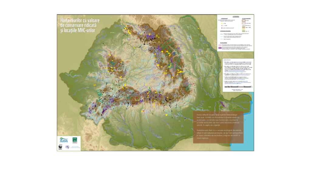
Legendă
I. Infrastructură:
Amenajări hidroenergetice aflate în proces de autorizare, construire sau operare (de maxim 10MW)
 putere instalată necunoscută
 < 1 MW
 1 – 10 MW
II. Elemente hidrografice:
—Corpuri de apă extrem de rare având o stare ecologică foarte bună (<3% din suprafaţa totală a râurilor din România)
—
Corpuri de apă având o stare ecologică bună şi o stare a albiilor (hidromorfologie) foarte bună
—Rețea hidrografică
III. Arii protejate:
Arii naturale protejate de interes naţional (rezervaţii ştiinţifice, parcuri nationale, monumente ale naturii, rezervaţii naturale, parcuri naturale) şi de interes internaţional (geoparcuri).
Situri de importanţă comunitară (SCI-uri) desemnate pentru protejarea speciilor de peşti, vidra şi rac şi pentru habitatele acestor specii (conform Avizului de Mediu nr.10938/2012 pentru Strategia Energetică a României), precum şi pentru păduri galerii de anin.
Technical team: Claudia Blagu, GIS specialist; Greg Bugyis – Web Developer1 Această hartă este conceptul exclusiv al WWF creat în scop educativ şi ştiinţific. WWF consideră această hartă un punct de plecare în procesul de desemnare a zonelor de excludere pentu construcţia de amenajări hidroenergetice; stabilirea criteriilor finale, desemnarea acestor zone şi cartografierea lor ar trebui efectuată în cadrul unui grup de experţi stabilit sub coordonarea Ministerului Mediului şi Schimbărilor Climatice, cu participarea tuturor părţilor interesate, inclusiv organizaţii de conservare a naturii.
SURSA DATELOR
***Informațiile cu privire la amplasarea amenajărilor hidroenergetice au fost furnizate în perioada iunie 2012 – august 2014 de către Agențiile pentru Protecția Mediului în baza Legii 544/2001 privind liberul acces la informația de interes public.
***Informaţiile cu privire la ariile protejate de tip SCI, rezervaţii ştiinţifice, parcuri naţionale, monumente ale naturii, rezervaţii naturale, parcuri naturale şi geoparcuri au fost obţinute de pe site-ul Ministerului Mediului şi Schimbărilor Climatice de la adresele:
https://biodiversitate.mmediu.ro/rio/natura2000/
https://www.mmediu. ro/protectia_naturii/protectia_naturii.htm
***În cazul parcurilor naţionale, parcurilor naturale şi geoparcurilor unde a existat o zonare a acestora, fiind prezente zonele de protecţie integrală, aceste zone au fost marcate printr-o nuanţă mai închisă.
***Informaţiile cu privire la starea ecologică a râurilor au fost obţinute de pe site-urile: EIONET Central Data Repository https://cdr.eionet.europa.eu/ro (vezi licenta privind sursa : https://cdr.eionet.europa.eu/legalnotice ); şi Administraţia Naţională Apele Române https://www.rowater.ro/SCAR/Planul%20de%20management.aspx
***Datele privind apele curgătoare de pe teritoriul României au fost obţinute de la adresele: https://www.eea.europa.eu; (licenta privind sursa: să nu utilizeze datele / aplicațiile pentru scopuri comerciale cu excepția cazului în care Agenția a acordat în mod expres dreptul de a face acest lucru) Ministerul Mediului și Dezvoltării Durabile: https://www.mmediu.ro și Institutul Național de Cercetare-Dezvoltare “Delta Dunarii”: https://www.indd.tim.ro
Ţinând cont de faptul că există câteva neconcordanţe între reţeaua hidrografică şi limitele ariilor protejate, precum şi lipsa unei cartări detaliate în România, rezultatul final fiind bazat şi pe interpretarea specialiştilor implicaţi, WWF nu garantează acurateţea 100% a informaţiilor prezentate şi nu îşi poate asumă răspunderea pentru orice fel de interpretări ale unor terţe părţi. Date aferente acestei hărţi (indiferent de tip) nu pot fi utilizate în scop pur comercial, cu excepţia cazului în care organizaţia a acordat în mod expres dreptul de a face acest lucru.


Material realizat cu sprijinul financiar din partea Mava Foundation, Fundației pentru Parteneriat și Trust for Civil Society in Central and Eastern Europe (organizaţii care nu îşi asumă responsabilitatea pentru conţinutul harţii).
English version
 Capacity Unknown
 < 1 MW
 1 – 10 MW